Headquarters
The Energy and Resources Institute (TERI)
Darbari Seth Block, Core 6C,
India Habitat Centre, Lodhi Road,
New Delhi - 110 003, India
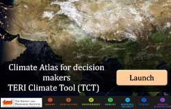
New Delhi, 15 October 2020: The Energy and Resources Institute (TERI) launched a climate atlas in the form of a web portal called 'TERI Climate Tool' or TCT to assist policy planning at the regional level and help decision-makers to be climate ready.
The atlas has been developed under the project PREPARE, under phase 2 of the Norwegian Framework Agreement between TERI and the Norwegian Ministry of Foreign Affairs. At the virtual event, TERI also launched the Flood Early Warning System for predicting urban floods for Jorhat city (FEWS-J) in Assam. Replicable for any part of India, the FEWS-J tool provides a warning with a lead time of 72 hours about flash floods or heavy rainfall.
Delivering the keynote address Shri Jishnu Baruah, Additional Chief Secretary, Government of Assam, Revenue and Disaster Management Department, said, "Science-based tools such as TERI Climate Tool (TCT) and Flood Early Warning Systems (FEWS), backed by robust scientific knowledge, are necessary to mainstream robust climate information, early warning and risk reduction services into policy and decision-making.
"Assam faced three waves of floods this year which impacted 30 districts. ICT enabled tools are essential for the mitigation of risks and to expand the regional disaster risk reduction efforts of various cities in Assam including Guwahati and Jorhat, located at the banks of the Brahmaputra River," the Secretary added.
In her special address, Ms Camilla Dannevig, Counsellor Cooperation, Embassy of Norway to India, said, "Norway highly prioritises the cooperation with India on environmental issues and climate change. Norwegian scientists and companies have cutting-edge knowledge and experience in the areas of environmental management and technology. Cooperation with India offers considerable opportunities for Norwegian actors, who can assist India in addressing the climate challenge."
Speaking at the launch event, Dr Ajay Mathur, Director General, TERI said, "About 12% i.e. about 40 million hectares of India's geographical area is subject to riverine and flash floods. Hydro-meteorological disasters especially flood has the highest percentage share of total deaths in India. The climate science based tools have a significant role in enabling the policy decisions of tomorrow. India needs to prepare now. The focus should be in the direction of making cities and other areas climate-resilient."
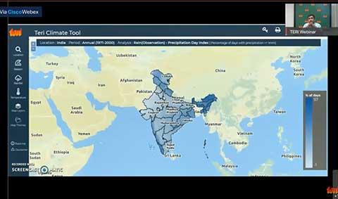
Highlighting the benefits of the tool, Mr Saurabh Bhardwaj, Fellow, Earth Science and Climate Change, TERI said, "Our tool has been conceptualised to address the current gap in the understanding and provisioning of scientific knowledge towards regional policy planning. This first of its kind tool provides information on climate variables like temperature, precipitation, and various climate statistics including extreme climate indices for past and future time period over national, state wise, district wise and city scale."
He added, "Decision makers, practitioners, policy makers, researchers, all can draw out easy reference via this tool on high resolution for any part of India. The tool has huge potential in aiding climate-related sectoral planning for agriculture and water sector."
The atlas provides the stakeholders with timely, tailored climate-related knowledge and information that can be used to reduce climate-related losses and enhance benefits, including the protection of lives, livelihoods, and property. The atlas also strengthens the state-level authorities in drawing regional climate risk sectoral information and incorporating them in the ongoing revisions of State Action Plans on Climate Change. It includes:
Multi-Scale Data
Multi-parameters
Visualisation
Shri M S Manivannan, Chief Executive Officer, Assam State Disaster Management Authority, said, "There is a need to strengthen community level response systems in urban areas of Assam. The IMD tool and TERI tools can be used effectively together to help us address issues of flooding in Assam."
Annexture 1: View the Features of TERI Climate Tool
The Energy and Resources Institute (TERI) is an independent, multi-dimensional organisation, with capabilities in research, policy, consultancy and implementation. It has pioneered conversations and action in the energy, environment, climate change, and sustainability space for over four decades.
The institute's research and research-based solutions have had a transformative impact on industry and communities. Headquartered in New Delhi, it has regional centres and campuses in Gurugram, Bengaluru, Guwahati, Mumbai, Panaji, and Nainital, supported by a multi-disciplinary team of scientists, sociologists, economists and engineers, and state-of-the-art infrastructure.
For further information, contact:
TERI – Dhawal Trivedi: dhawal.trivedi@teri.res.in
Edelman – Rakhi Aurora: rakhi.aurora@edelman.com