Case Study Site
The project will be undertaken in the drylands of Maharashtra. The state of Maharashtra falls in the Western Plateau and hills region, which is one of the 15 resource development zones into which India has been divided. Major portion of the state is semi-arid with three distinct season of which rainy season extends from July to September. The quantity of rainfall has large variations across different parts of the state. While Ghat and coastal districts receive an annual rainfall of 2000 mm, large regions of the state lie in the rain shadow belt of the Ghat with an average of 600 to 700 mm . More than 30% of the state falls under the rain shadow area. The State of Maharashtra comprises four regions: from the coast inward these are Konkan, Western Maharashtra, Marathwada, and Vidarbha. The normal annual rainfall in Marathwada is low, and it is characterized as a frequently drought prone area, with drought expected every six to ten years. 2012 has also been a drought year for this region.
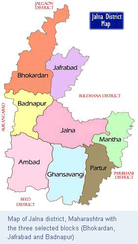
The Marathwada region is one of the five regions in Maharashtra and largely covers the Aurangabad division of the state. The region comprises of 8 districts of which the Jalna District has been chosen as the case study site for the pilot phase of this project. Jalna district falls in the dryland region of Maharashtra. With a population of 1,958,483 persons in the 2011 Census, Jalna is among the less populated districts of Maharashtra .The population density of Jalna district is 255 and in the last decade (2001 -2011), Jalna has seen a population growth of 21.84%. Three clusters of three villages each have been selected for field work under this project. The clusters include Bhokardan, Jafrabad and Badnapur.
Key Vulnerabilities:
- Climate: The district of Jalna in the state of Maharashtra lies is largely a dryland. Jalna falls under the list of districts covered under the Drought Prone Areas Program by the Department of land resources, Ministry of Rural Development, Government of India. Jalna district has a semi-arid climate regime with most of the rainfall occurring during the southwest monsoon months, between June to September. The annual rainfall of the district ranges between 650 to 750 mm with an average of 725.8 mm. The district often experiences drought with rainfall recording as low as 400 to 450 mm. There is some variation in the rainfall pattern across the blocks constituting Jalna district, with the northern blocks (Bhokardan, Jafrabad, Badnapur, and Jalna) recording lower rainfall than the southern blocks (Ambad, Ghansavangi, Partur, and Mantha).
- Groundwater: Analysis of groundwater level from 1998 to 2007 shows that in almost entire district there has been a decline in groundwater level in both pre-monsoon and post-monsoon period. Of the 23 out of 25 stations there has been a fall in groundwater level ranging from 0.05 to 0.52 m/year during pre-monsoon and from 0.01 to 0.78 m/year in post-monsoon period.
- Large dependence on agriculture for livelihoods: Almost 77% of the land area of Jalna district is under agriculture. The dependence on agriculture for livelihoods of the communities is substantially high. However, only 13% of the area is irrigated, which indicates the climate sensitivity of agricultural livelihoods.
- Socio-economic characteristics: Jalna is among the lower income districts in Maharashtra. The district performs relatively poorly on gender indicators. The female literacy rate is low compared to the national average of 65% and the 0-6 years sex ratio has declined alarmingly over the last decade.